Original Review date: August 2018. fēnix 5X Sapphire tested with Garmin Run HR Strap and 5.30-10.0.0 firmware
Note: we’ve changed some methods behind the scenes to enable fairer comparisons between models. So figures are not comparable with earlier reviews (until they get updated).
Summary
Hello everyone, you may recognise me from previous MEC reviews like the orignal fēnix 3. I’m back with a few updates, good and bad. Accuracy has improved, the shed-load of features is added to, big additions being basemap with auto-roug capabilites and an optical HRM. The altimeter accuracy is among the best we’ve seen yet and distance accuracy in easy conditions is solid. Unfortunately it all comes unstuck in difficult GPS conditions, where distance accuracy is still pretty much bottom of the group, with battery life also suffering as the GPS struggles to cope. Even with UltraTrac on there’s no guarantee it’ll even make 20hrs if there are trees on course. The kicker being that the’ve dropped the wearable charging cable design from the fēnix 2/3. That said, if you are a fast 100km’er or short trail runner and are happy wearing a footpod there’s a lot to like.
A current model round-up can be seen here, and the testing methodology is here
What kind of trail runner is it good for?
A tree hater, Cantabrian, arctic dweller, rapid alpinist, or fast footpod lover. The fēnix 5X really doesn’t like sky obstructions, but performs very well under an open sky and has excellent elevation accuracy. With an extensive feature set, trail gadget geeks will be well impressed. The navigationally challenged will also benefit from the map and auto-routing functions. While the trail distance accuracy issues can be avoided with a good footpod, 100 miler types are safest avoiding it given unreliable endurance performance.
What should you expect as a long term running companion?
The fēnix 5X is pretty reliable during normal trail activities (within its endurance, tree-hating limits), after a few thousand kilometers on the wrist there have only been a few instances of the watch spacking out. Firmware updates have been plentiful and undisruptive, though sadly haven’t seen any performance improvements along the way (perhaps aside from the optical HRM). The build appears solid enough, no screen fogging, scratches, obvious wear aside from strap texture smoothing out a little. As a long term owner you are are likely to suffer syncing issues from time to time – though with multiple options there’s usually a workaround. And if you like going loooong you are likely to start developing a case of range anxiety.
Good Stuff
An extensive set of useable features for trail/ultra-running, excellent tactile buttons, a well designed user interface, and a great customisable display. Plays nicely with other brand BLE/ANT+ sensors, data is directly accessible via the widely supported FIT format. There is excellent control over footpod data, you can manually calibrate them and specify whether to use them for speed and/or distance. Garmin remains impressively open with active third party development interfacing web services and watch features. Mobile app works well with both Apple and Android (in most firmware versions). The map and auto-routing/navigation options are fantastic, with the widely used Garmin map format you can even bring your own custom topo maps to it. Segment alerts are fun for the baggers out there. Easy GPS condition distance accuracy is great. The altimeter is among the best we’ve tested. The optical HRM can even give sensible looking data if you don’t push the running intensity too hard.
Bad Stuff
For a flagship outdoorsy GPS watch the fēnix 5X the accuracy under tree cover is disappointing plus. It scored the among lowest in difficult GPS conditions over the test group in absolute distance accuracy and the group includes a phone and a model that’s been out of production for more than 5 years. Battery life appears to be a gamble, it looks good to go close to 20hrs in easy conditions with normal GPS, but has died in less than that under tree cover using UltraTrac. The change in cable design means no more battery I.V. hookups. We’ve had syncing issues on and off with both the Garmin Express (PC) and Garmin Connect Mobile (Android), it seems WiFi is the most robust option but not sure if it syncs the satellite libraries as we’ve had to wait minutes at the start of a run for a fix when these issues occurred.
Plea to Garmin
Garmin has produced GPS that perform well in all conditions, the venerable FR910XT is proof of that. Sadly though accuracy under difficult conditions appears to have been deprioritised (disregarded?) over other design considerations in the fēnix 5X. It also seems that this has a knock-on effect of compromising battery. Accuracy and endurance in actual outdoor environments are kind of the point of a GPS watch marketed towards outdoorsy types. So bumping up real world trail performance in the fēnix line would be nice.
Some feature requests too (the same as we had for the fēnix 3), an easy way to optimise battery life when setting up a sport/app (ie. turn on UltraTrac, turn off bluetooth, adjust backlight, etc). And the return of some sort of positional lapping (waypoint or first lap press).
Also the PC version of Garmin Express could use a bit of sorting, we are forever having issues updating maps or refreshing syncs with it.
Formal Testing
Accuracy
The GPS pool against which the fēnix 5X was tested included the following models: Suunto’s Ambit2, Ambit3 Peak, and Spartan Ultra, Polar’s V800, Garmin’s FR910XT, fēnix 2 and fēnix 3, and a Sony Xperia Z5c running the SportsTracker app.
During testing multiple GPS devices are carried as a means of validation, if all units have a bad GPS day then a tin foil hat is donned. Though some days with poor GDoP potential saw all units a little degraded, no testing days saw GPS chaos across all models.
So far standard fēnix 5X testing has covered in excess of 360km on the surveyed courses over 30 separate days with a total of 164 recorded laps (though we’ve clocked up around +3,300km with normal running duties). Outing conditions included rain and shine, night and day. Our testing is designed to provide a statistically robust measures in real world conditions – check our methodology here.
Note: Aside from the overall figure, which tells us if will run long or short in your overall logbook, we report distance accuracy using absolute percentage accuracy. In other words 5% wrong is 5% wrong, it doesn’t matter if it’s long or short, they don’t cancel each other out during your run.
Distance
Overall the fēnix 5X recorded 97.4% of the total surveyed distance run which was a smidge under the overall test group average at 97.9%. This means if you run in a variety of conditions similar to our test grounds your fēnix 5X logbook will be 2.6% short.
Under easy and mixed conditions the fēnix 5X does very well indeed, recording absolute accuracy percentages of 98.7% and 98.6% respectively. These are both slightly up on the group average. However difficult conditions the fēnix 5X drops to near last place recording 95.0%. By comparison the best performers came in at 99.1% (easy) 98.9% (mixed), and 96.6% (difficult).
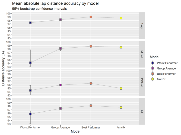
What the overall accuracy (bottom panel on the chart) would look like for you depends on what conditions you typically run in. Overall our testing is balanced at 45% easy conditions, 30% mixed, and 25% difficult (but not what we’d call seriously challenging).
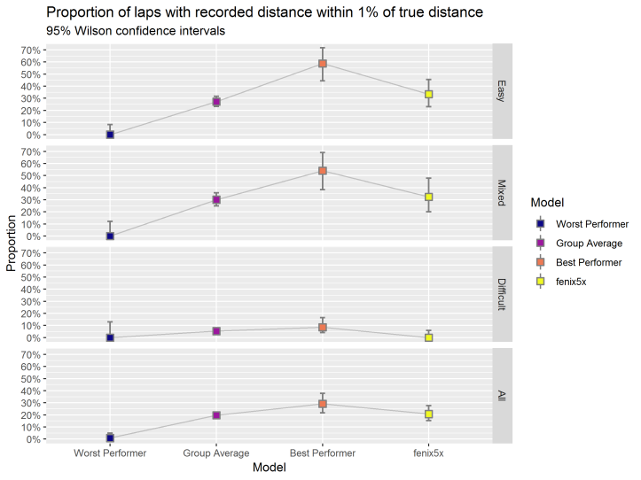
At this point you might be thinking those margins are pretty small, practically the same. But there’s another way to look at accuracy where we call each recorded distance within 1% of the truth as a success. Think of it this way – you’ve just run a 10km PB and you want your glory on Strava or the online service of your choice. But your watch shows 9.9km at the finish, so no digital PB, and no bragging rights for you. So even a 1% error can be a downer, let alone 5%.
Our ‘within 1% success test’ is much more sensitive at identifying how spot on each recorded distance run is. The differences between models now becomes a lot more pronounced. Here the fēnix 5X recorded within 1% of the true distance 34.1% of the time in easy conditions compared with 58.5% for the best performer and 27.9% for the group average. This figure plummets for all models under difficult conditions with the fēnix 5X coming in at 0% (yes zero), 8.7% for the best performer, and 4.5% for the group. Combining all results the fēnix 5X records 20.7%, just above the group average at 19.5%.
So what gives
When we plug all the factors we record into a (generalized linear) model to show us which are associated with distance accuracy we can see the fēnix 5X is strongly effected by tree cover, and moderately effected by by a general measure of satellite availability but not by track bendiness or average speed. On the other hand the raw GPX feed accuracy (also effected by tree cover and satellite availability) is predictive of good distance performance.
One interpretation is that whatever dead reckoning smarts the watch has, it doesn’t adequately compensate for poor GPS performance in difficult conditions.
Settings
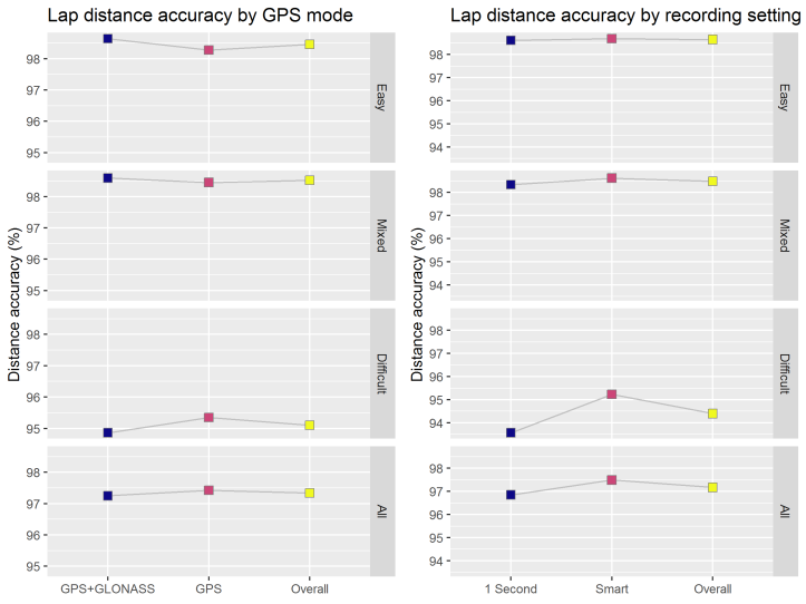
The fēnix 5X was tested with GLONASS on and off, 1 second recording and smart recording under firmware ranging from 5.30 to 10.0.0. The vast majority of outings were on the standard GPS (no GLONASS) with smart recording, though the GPS+GLONASS setting wasn’t independently tested of the smart vs 1 second recording so results aren’t independent.
While the numbers of outings under the various setup permutations was pretty limited, we did see some hints of performance differences. GPS+GLONASS accuracy in easy and mixed conditions appear to improve slightly over GPS alone, though interestingly the opposite was true under difficult conditions. Smart recording appears to be a better bet under all conditions. So using GPS only with smart recording seems the best general use option, which has the added bonus of minimising battery drain and log sizes.
Positional
The positional performance of the fēnix 5X is sub-average across all conditions. Under easy GPS conditions the median track offset distance was 1.9 metres (average 2.6m), falling to 3.3m (median 4.0m) under moderately difficult conditions. And 3% of points on the surveyed course were 10 or more metres off track where better performing models had <0.5% greater than 10 metres off track during testing.
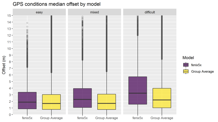
Note: positional accuracy is measured as GPS trackpoint to the closest point of a surveyed track (or repeat track where course is un-surveyed), so figures reported here will be a lot better than the actual positional accuracy.
Satellite vs Watch Distance
And for the nerdier types among you, here’s how the watch recorded distance lines up with it’s raw satellite distance. The charts also show how each and every recorded lap distance pans out over the course of testing.
The recorded distance you see on the watch is in purple (at the back) whereas the yellow is from the unfiltered gpx track. The vertical lines are the averages of the two. Our general performance expectation would be for the filtered recorded distance to be a tighter distribution that pulls the average distance closer to 100%. And indeed this is what happens with the best performing watch we’ve tested.
Garmin’s filtering is a bit of mixed bag. In easy conditions the watch recorded distance is slightly up on the GPX distance while it drags distance down for other conditions. You can also see the deterioration of lap accuracy in the difficult GPS conditions.
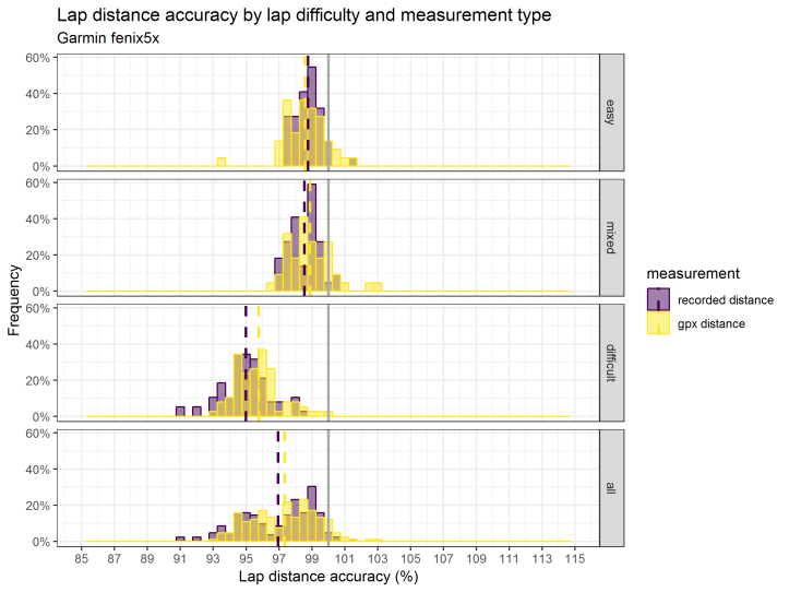
When the fēnix 5X was taken into genuinely difficult conditions (heavy tree cover, steep terrain, gorges), repeats of an 8km circuit showed the track appearance as typically slalomed in the more challenging section but otherwise quite good. The average track separation between laps was a pretty respectable 5.6m. Similarly good here, relative to other tested watches, was the recorded distance which came in about 5% long of the estimated (partially surveyed) track distance. Interesting these are all a little above the group average even though on our surveyed course the watch score near bottom in less difficult conditions.
Unfortunately this testing area is now closed to the public so no retesting was able to be done. With other models the retesting frequently showed very wide variations. We’d really need to get more data on this before we could interpret the results with any confidence. Still it was nice to see a relatively good outcome is possible in tough conditions.
Track Appearance
Under easy GPS conditions tracks generally appeared reasonably sharp and generally reflective of reality. There are occasions where the fēnix 5X goes a bit AWOL even in easy conditions but these are rare. Tracks are unsurprisingly a little looser in more difficult conditions.
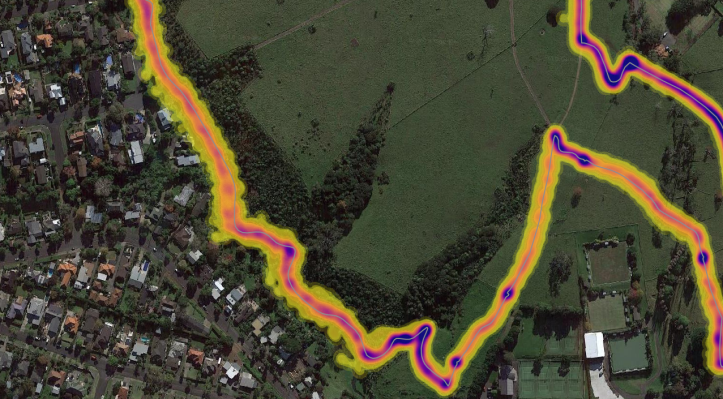
The trackpoint cloud image below shows the density of GPS position updates from all recorded runs against part of surveyed course. While the relatively open sky view conditions (tracks to the right) appear relatively tightly distributed around the track, the limited conditions (track on left) shows some consistent offsets, and a bit more dispersion and shadowing (running parallel to but well off the course).
Elevation
Elevation range, if manually calibrated at start, was very good. The total logged climb on the surveyed course was the best of the bunch coming in at an average of around 98.6%, well above the second best model at 90.4%. On an absolute (ie. wrong is wrong) per outing basis the performance drops to second at 89.3% indicating that some outings decently overestimate elevation. And it topped the group again in the proportion of outings that were within 10% of the true elevation climbed at 81.5% of outings. Nice.
An altimeter grumble here (just like the fēnix 3) is that unlike recorded activities the widget based altimeter/barometer does not continuously correct. I’d often wake to find my house was 40m below sea level which, despite climate change isn’t yet the case. Also if I run or ride into work which is about 110m higher that my house I’d frequently arrive to a storm alert.
Note: The survey course possibly is a bit tough on GPS watches with respect to elevation with lots of rapid 10-30m climbs/descents. Watches would probably perform better on longer more pronounced climbs/descents.
Battery Saving Data Recording
The fēnix 5X’s still drops trackpoints every 2 seconds on UltraTrac, but derives pace and distance and travel direction from available accelerometers and sensors. It’s unclear how frequently the GPS actually samples and we’ve not bothered to dig to find out. UtraTrac mode tracks typically show minor deviations to direction to be rather exaggerated. Running in challenging GPS requirements also sees the odd teleport, we’ve seen multiple jumps in trackpoints of over a kilometer. These are in general direction of travel but it looks like UltraTrac is having trouble reacquiring a satellite lock. Also worth noting UltraTrac doesn’t work so well with route navigation functions, it’ll constantly annoy us with off course alerts.
Our limited UltraTrac testing (without any external sensors) on the surveyed course had a tendency to run long under all GPS conditions and the variation is pretty wide compared to standard GPS settings. Sadly we haven’t done enough testing to give a clear picture on consistent accuracy using UltraTrac but there are suggestions that it can record better distance accuracy under difficult conditions than standard settings.
We also haven’t tested the performance of UltraTrac in combination with a Garmin Run or Tri HR belt so can’t comment on whether those sensors improve things at all. What definitely improves it though is the use of a decent footpod to give distance and pace. Unless you’re facing extreme conditions we’d recommend always using a footpod with UltraTrac mode. In fact, we’d always use a foopod with the fēnix 5X when encountering tree cover.
Battery Run Down
Battery life appears to be a gamble. The first easy condition endurance running test of 14:00hrs using a ANT+ HR strap, standard GPS, smart recording, and phone disconnected it sailed through with 28% remaining. Great. We’ve also run a 17:40hr event above the treeline with it same settings as above but with UltraTrac on and a ANT+ footpod and it came in fine (sadly the remaining battery notes were lost). Good-o.
Though on another outing the watch died after 18:45hr of running as neither watch nor runner completed the 2018 Tarawera Ultra 100 Miler (though to be fair the runner got further than the watch). Settings were the same as the earlier UltraTrac outing above. The difference here is the event was close to 100% under tree cover. Less than 20hrs endurance using UltraTrac is pretty sucky.
Seems like your mileage will definitely vary depending on what the GPS conditions are like. It is entirely possible that the fēnix 5X could get to 20hrs on standard GPS mode under open skies (though we’d use a HR strap to be sure). Though even using UltraTrac mode, heavy tree cover seems to kill endurance, and I wouldn’t bet on getting 24hrs from it.
More testing required to really nail down the fēnix 5X’s endurance limits but one failure in three doesn’t inspire confidence.
Functional Tests
Data Syncing and Sharing
All recorded activities can be automatically synced to a number of 3rd party services via Garmin Connect. Additionally Garmin Connect allows services to sync non Garmin activities into Garmin Connect. Multiple syncing options are available with computer-cable, mobile-BLE, and WiFi-direct capability. As a bonus when the fēnix 5X is connected to a computer it is effectively mounted like an USB drive so data is directly accessible for 3rd party desktop apps (even if it’s already been synced via mobile).
Sadly though we’ve had frequent issues with Garmin Express on a PC, updating maps frequently fails, and syncing appears to be incomplete, refreshing always invokes a communication error message. We’ve tried reinstalling Garmin Express, used different USB ports (incl USB2), different PCs, and resetting the fēnix 5X. The Garmin help desk to date has been less than helpful. Pretty clear they didn’t even read the original message as they suggested something we had already tried. I’m wondering if it might be a cable issue at this point. The Garmin Connect Mobile app (Android) is also a bit hit and miss though if you are patient and retry a few times it’ll eventually get there.
We’ve been through periods of waiting a few minutes for the fēnix 5X to lock on to satellites, presumably related to the PC syncing issue. Though we’ve been syncing via WiFi so we would have thought the satellite library would be updated by that.
Navigation Functions
Track/Route/Course Stuff
So here’s the shiny big feature of the fēnix 5X, mapping and auto-routing, and all up it’s pretty impressive. Though from a testing perspective it was rather complicated given the numerous options in creating routes/tracks to follow but I guess most users will go for the simplest option. If you really don’t care about the detail you can skip to the smiley a couple of para down…
Historically there was difference between a track and a route, or whatever Garmin currently calls them (in Garmin Basecamp they are track/route, but only ‘Courses’ exist on the fēnix 5X and Garmin Connect). A track is just line made up of breadcrumbs (trackpoints), whereas a route is a connected series of waypoints. And routes come in two flavours, direct and auto-routing. Direct being a straight line between the waypoints, and auto-routing following available map roads/trails. But you can also add waypoints to a track. Clear?
Historically you had to hand trace a track, or use an old activity, but Garmin Basecamp, Garmin Connect, GPSies.com and any number of online services provide auto-routing to draw the lines between the points you click. But auto-routing is a route not a track. And even if you have an old GPX file (track!) you dump directly onto the fēnix 5X, you can set up the watch to reinterpret it as a route with the activity ‘Use Map’ setting. It’s all very confusing, perhaps that’s why they just refer to them as ‘Courses’. And doesn’t really matter so long as you get what you want.
And what we generally want for trail running is a 3D line with some points along it to alert us to stuff. Then get navigation guidance along this line with the ability to see the elevation profile of the line, the total distance and estimations of time/distance/climbing remaining to both the finish and intermediate points. What we don’t want is too many alerts, and simple line of sight distances.
And yes you can get all this with the fēnix 5X if you use Garmin Connect to make your ‘Course’. You can create a line by following roads or freehand and add named points to it once it’s drawn. And you’ll get distance/time info on them and be alerted on approach to each named point. But there’s a slight catch, you’ll also be alerted to each unnamed shaping point you clicked when you created the line. So if you don’t want too many alerts, don’t use too many shaping points to create your line, and unless you want a turn by turn alert keep the activity setting to ‘Follow Course’.
But if you use Garmin Basecamp to create your (auto) routes there’s no way of keeping the functions waypoints with the track/route when transferring directly to the fēnix 5X . And you probably want to use Basecamp to manage your waypoints (‘Saved Locations’) if you have a lot of them. If you do create a ‘Course’ to follow using Basecamp you can separately add proximity alerts on the watch itself from Saved Locations (aka waypoints) to get the alert bit, but not the intermediate distance/time estimates.
Still with us? You can also create a Course (route) directly on the fēnix 5X using ‘Saved Locations’ (waypoints). The trick here is each activity type on the watch has it’s own options for which map to use routing type (direct or auto-routing), and ‘Follow Course’ or ‘Use Map’. It’s here you set whether the fēnix 5X will just follow the course as is, telling you if you’ve gone astray, or attempt to re-route you using its onboard maps. Which is all fine and dandy once you’ve set it up but a little non-obvious to start with. It’s also worth noting that the initial distance on a route made on the watch is that the display distance is direct not auto-routing, though the en route stuff is as per the calculated course.
🙂 [smiley]. So there you have it. Generally we make our trail Courses on Garmin Connect and set the activity routing to ‘Follow Course’ as the turn by turn alerts are a bit excessive if you hit plenty of junctions.
Map Stuff
We were initially pretty skeptical about the map function on a screen that small. And it is small, but functions build around the mapping capability make it pretty useful at times. If you are at a junction with multiple options the map is good enough to take the right path. You’ll still want to create longer ‘Courses’ on a computer and transfer it (see above), but the ability to navigate by trail (not line of sight) to locations close to where you are is well thought through. A feature that has proved useful a few times is the navigate back to start by the shortest auto-route (ie. not necessarily the way you came).
Naturally the route based navigation is only as good as the available maps, and Garmin have a map format that enables users to make their own as well in addition to commercial and open source products. Being the running nerds that we are we’ve been making our own for years which combine official government sources (waterways, landuse, contours and natural stuff) and OSM (tracks, roads, pubs, and man-made stuff). We started this due to frustrations with commercial sources being incomplete and out of date and our blended source approach means we’ve got good data and can easily update our topomaps with the latest tracks and pubs.
We’ve also marked some marked routes on the maps (NZ’s Great Walks, Te Araroa, and a few others) to make pathfinding easier. And the maps work great on the fēnix 5X. We can even use them find our way to a decent pub after the run directly from the watch.
You can download our NZ topo maps for free here (it’s legit, promise) –
https://mega.nz/#F!V58gmDwQ!aHq1n7jIKPtw4e-ePAcprg
General Navigation Stuff
So putting it all together with a Course plotted you get a heading bug on all screens (a little red arrow to follow), can get distance remaining/ETE/ETA on intermediate course points as well as the finish, elevation profiles to follow, and a map. And you can customise the navigation screens as you like. Even we couldn’t get lost with all that. Where auto-routing is used waypoint/finish distances are by the trail not line of sight.
A navigation feature we haven’t used much but would be of some value if you travel off track a lot or don’t have maps of the area is Sight N Go. It’s basically like a relative bearing from your current position to whatever you are pointing at. As it doesn’t know how far away that thing you are pointing at is you may have to repeat sightings if you are making big detours.
Though what it does give you is the distance you are off the bearing line, and strangely a distance remaining from when you took the sighting from a fixed distance. What is particularly strange about it is that the distance is fixed to 80.4 which appears to be be derived from an archaic standard of distance set by the British Parliament back in the year 1593. That is, 50 statute miles.
Finally, it would be nice to get the Course waypoints to automatically lap the activity. You could do this to a limited degree with the old FR910XT, by positional lapping and we still miss it.
Pacing and Segment Functions
The fēnix 5X has two options on pacing yourself during an activity. The virtual partner one sets off at a constant pace, not slowing for hills or bogs or salt and vinegar chips. The better option for trail types is the ability to race previous activities, either your own or your invisible friends. This is races you against a real-time play back of the previously recorded activity and is a much better option for mixed terrain running.
The watch also integrates Garmin and Strava segments that enables you to download segments. Once on the watch they alert you when you approach the start and give you some info about the segment, then it’ll give you an encouraging start and finish countdown. If you are motivated by segments, then this is a great feature for you.
In our experience this seems to be a little bit hit and miss, as segments aren’t always picked up while running. Also this doesn’t seem to work if you are using navigation functions.
Standard Feature Set
General Trail Running
- GPS accuracy under canopy : Poor
- Consistent GPS accuracy : Yes(ish)
- Rapid GPS Acquisition : Good(ish)
- HRM : Yes
- Cadence option : Yes
- Battery 8hr with HRM and high accuracy setting : Yes
- Barometer : Yes
- Breadcrumb with waypoint navigation : Yes (and auto-routing!)
- Vibration alerts : Yes
- Trail legible display: Excellent
- Open data access : Yes
- Fully ANT+ or BLE Compliant : Yes
Ultra Feature Set (as per trail running plus)
- Battery 14hr+ with HRM and high accuracy recording : Yes
- Battery 24hr+ with HRM and down-sampling : Likely condition dependent
- Electronic compass : Yes
Nice to Have Features
- Mobile uploads : Yes
- Cadence (without footpod) : Yes
- HRV (R-R) recording with recovery estimate/test : Yes
- Footpod GPS override : Yes
- Basic interval workout ability : Yes
- Pacing function : Yes (fixed pace and past activities)
- Position/waypoint autolapping : Sort of with an IQ App
- Custom timer reminders : Yes
- Everyday watch : Yes
- Activity Tracking : Yes
- Mobile Notifications : Yes
Non-Tested Core Features
While functions like heart rate and cadence are core, either we’ve got no means of objectively testing them.
Across all runs with the fēnix 5X cadence and belt based heart rate appeared pretty consistent with the other units. Running with a footpod showed no obvious cadence differences to that of running without. Standard transmitting footpods can be manually calibrated which is always a good idea, no matter the model. We haven’t run without the Run HR belt so can’t comment on its effect on the fēnix 5X’s performance generally. The optical HR sensor now works pretty well for low intensity activities but once you get up to tempo level it no longer gives us sensible data.
After sporting the fēnix 5X for all activities over a year (only a subset were part of the formal testing), I’m not really sure what to make of the recovery checks and the like. It seemed a bit random at times, though perhaps weren’t consistent enough in our useage of it. Best hunt around for other reviewers with something to say here.
General Useability
The overall design of the fēnix 5X is fantastic, the screen is highly customisable and legible day and night (we love the wrist tilt backlight). The alert vibration is strong, beeps audible, and buttons feel positive with instant response. We are fans of lots of buttons that do the same thing irrespective of screen/mode, makes it easy to rote learn even when ultra brain fade sets in. Having buttons conditional on stuff or touchscreens can be cognitively or physically challenging when things get tough.
A really nice thing about the level of data customisation, the buttons, and the screen is that you can really dumb things down for when you are racing or out for +12hrs. In these scenarios we generally only want a small number of items (how long till sunrise? how far have we gone?, etc.) in really large font, with super simple buttons (start/stop, lap, backlight, scroll).
If you want lots of data and lots of screens you are all sorted there too. You can break many things down by laps (current and last), and mix and match to your hearts content. You can set alerts for timers, pace, heart rate, cadence, proximity, elevation, and run/walk timers. Though no alerts yet for Stryd power (at least we haven’t found it). It’s also well designed to set up relatively complex workouts rather than just regular time/distance intervals.
Satellite pickup time is typically rapid after syncing, <10 seconds with a reasonable sky-view. As noted though you are in for a long wait if your syncing fails.
Pairing the fēnix 5X to a raft of BLE/ANT+ sensors, including a Suunto ANT+ footpod was no problem. In fact as a tester it is a bit of a problem as it is greedy and will try to pair/use any sensor it can find. We’ve had the issue of it still using BLE sensors even when it was set to not paired to them. I guess the connection toggle only effected the ANT+ bit as it stole the Stryd’s BLE sensor from the other non-Garmin test watch. On the topic of Stryd the fēnix 5X has the best integration of any watch we’ve paired with it so far. With a couple of IQ Apps and ANT+ we can get footpod and power data and display them multiple ways.
What is especially good about the fēnix 5X is that even if you sync activities via mobile, or Garmin Connect the activity file is still available to be picked up by a computer for putting into a 3rd party application (SportTracks in this case).
The Garmin Connect website is as useable as any these days and integrates general health stuff from the fēnix 5X (steps, sleep, blobbing on couch/office chair). A number of services enable syncing activities into and out of Garmin Connect which is great for those with multiple devices. This is in stark contrast to the likes of Polar Flow and Suunto Movescount services which don’t accept any but their own, and make it hard to grab data directly off the watch to boot.
One issue to note is that the fēnix 5X has a bit of a dual identity, for running type activities the Garmin Connect website is where you’ll be lurking. For more outdoorsy adventures like off-trail ramblings you may be better off using Basecamp given it’s waypoint management capabilities.
The running features we use most are all easily accessible with minimal faffing. However, with this many features there are a lot of menu options that are not always intuitive. The initial setup, being via the watch itself was a bit painful compared to the computer based setup and sync approach of others. On the other hand you can adjust stuff whenever you like.
A feature of note for the mountain runners out there is the 3D distance/speed, we’ve just left them on though haven’t tested their effect in any way. There is now a large stack of externally developed IQ Apps, though we’ve only used the Stryd power and a positional autolap apps. Some other interesting looking apps out there though. While we get running dynamic data with the Stryd sensor we still don’t really know what that means on the trail, someone might though.
As previous indicated we’re not keen at all on the new charging cable design, the wearable version from the fēnix 3 seemed a much better option. Especially given the dicey endurance issues we’ve experienced.
Non-running features we liked included smart notifications on the watch, and a ‘find my phone’ function. These simply worked with no faffing via the Garmin Connect mobile app on Android.
Like shoes and backpacks, comfort is a personal thing – try before you buy.
Long Term Verdict
Currently over 3,300km clocked on fēnix 5X, including short and sharp trail races (3hrs), daily urban run/bike commutes, and some challenging trail outings. Longest recording was a 18:45hr trail run. Nothing new to add from outside of testing in terms of reliability, or other issues while running.
Despite the accuracy issue under NZ tree cover and the questionable endurance, the fēnix 5X when paired with a decent calibrated footpod makes for a great short course trail watch. Now if we could only get it properly syncing again.
